Sunday, November 15, 2009

A termination of Karatani-rindo (2009/11/7)

I went to Kiso Otaki area for checking a termination of Karatani-rindo.
This forest road is not described on a map of Geographical Survey Institute.
I was always interested where it reached.

This forest road has a total of approximately 6.9km.

BTW, the location "N35 50.190 E137 23.174" is available of a mobile phone(AU).

[The route of Karatani-rindo]


[The entrance of Karatani-rindo]


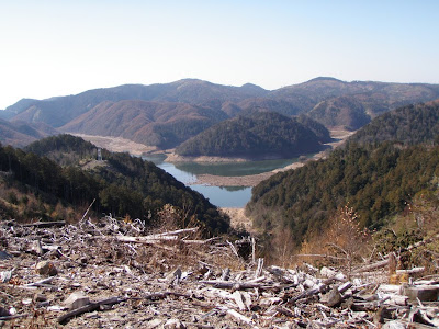
[The termination of this forest road]


[A view of Miura-dam]

[A view of Mt. Ontake]


[I forgot chopsticks... So I used a cane of a banboo glass.]

Sunday, November 1, 2009

Autumn color of leaves and a forest road  

I went to Miura-dam for watching colorful leaves. I had
another reason. I wanted to confirm a termination of a forest road.
That termination is located at here.
I almost ran by my bicycle around the Otaki-mura. However I still
do not run some forest road. This road is one of them.

I noticed that Mt. Ontake fumed from an unusual place. There are
earthquake swarm activities recently. I am concerned about those
phenomena. I wish those are worry about nothing...

[Mt. Ontake]


[The termination of a forest road]


BTW, this location is available for a AU's mobile phone.

Saturday, October 31, 2009

Magic Mouse

Magic Mouse has come!

I have felt that the might mouse would be so legacy shape
since the new mouse has arrived...

Sunday, October 4, 2009

September 27, 2009 A tributary of Otaki river

This fishing was a final of this season.
I went to shira-kawa.


[This fish would be a genuine yamato-iwana.]


[These were my systems of this season.]


[Orange dots are a token of yamato-iwana.]


This fishing season has been finished for me.
But, rivers run on there as usual.

September 26, 2009 A tributary of Kiso river

I went to Ina-gawa. This river is also one of a deep canyon in Kiso river.
When I reached a parking at 4:30AM, which is based for a trekking,
a fishing or etc., several cars have already stayed there.

I entered this river at a diversion weir.
Finally, I could not catch a fish!! But I felt fine because a water is
clear and all atmosphere was good. I know this is sour grapes:-)

[A diversion weir which is located at here]


[This dam is located at approximately "N35 43.981 E137 45.359".]


[I finished a fishing at this point]


After I exited this river, I went to Otaki river.
Then I caught a malformed fish...

[A malformed iwana]

Wednesday, September 23, 2009

September 22, 2009 Otaki river

Maybe, it was the last fishing of this river on this season...

[This fish would be a hybrid of a yamato-iwana and a nikko-iwana.]


Sunday, September 20, 2009

September 20, 2009 A tributary of Kiso river

I went to Nameri-kawa. I think this river has few fish...

[Wide view, the right side of the mountain is Mt. Ontake]


[Fall has come]


[Mt. Ontake]


[Nameri-kawa has several dam]


[Komagatake, Nakadake, Houkendake]


Thursday, September 17, 2009

September 13, 2009 A tributary of Otaki river

I went to a top water of Tuschiura-sawa.